


CFI Tools RouteWx app for iPhone and iPad
Developer: Edgemont Systems
First release : 27 Mar 2010
App size: 1.62 Mb
----------------------------------------
CFI Tools Route Weather - RouteWx
----------------------------------------
PURPOSE: The Route Weather App is used to display METAR and TAF data along a specified Route. The Route is defined by an Origin and a Destination and all stations within a given distance of the route.
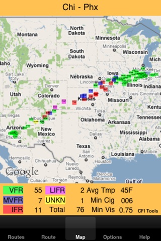
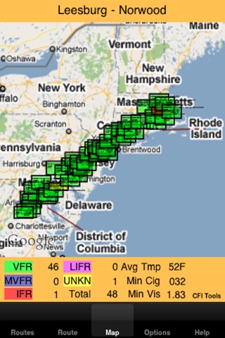
METARs on a Map
--------------------
The METAR data is displayed on a map that adjusts based on the Route. The METARs are colored coded based on the aviation flight category (VFR, MVFR, IFR, LIFR) for the station. The color coding and placement on the map gives a good quick overview of the current weather along the Route.
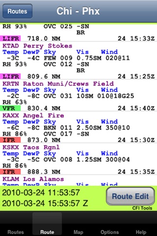
METARs in a Table
----------------------
The METAR data may also be displayed in a table that allows a more detailed view of stations along the Route. The stations are sorted based on their distance from the Origin station. Tap any station in the table to see the complete raw data for the METAR and if available the TAF.
How it works
---------------
- Define a Route
- Select an Origin and Destination airport from the database of over 4,000 airports
- Select the radius to be used to search for stations along the Route
- Select any additional stations to be included regardless of location
There is a fast search function that allows search by ID, airport name or city. After a stations are chosen simply enter the radius and touch Done.
An internet connection is required to get the METAR data.
Save Your Favorite Routes
---------------------------------
All defined Routes are saved in a file and may be used across multiple sessions. The Routes can be modified deleted or sorted based on your preference.
Quick View of Conditions Along Your Routes
----------------------------------------------
Every time the App starts you get a quick high-level view of your routes and the conditions (VFR, MVFR, IFR, LIFR) along each Route. Each station on the route is represented by a color-coded block and letter that indicates the current aviation flight category.
Options Tab
---------------
Measurement units for Wind speed, Temperature and Distance can be set on the Options Tab.
Airports in the Database
--------------------------
PLEASE NOTE: The source of the METARs used in this App is NOAA’s National Weather Service Aviation Weather Center. It can be found here:
http://aviationweather.gov/adds/metars/
If the METAR station can not be found with this site, it will not be in the App.
The database used in the App contains over 4,000 airports. If you would like to review the list of airports in the database you can see them in either an Excel spreadsheet or in a simple tab separated text file. The files are here:
http://www.edgemontaviation.com/cfitools/AreaWxAirports.xls
http://www.edgemontaviation.com/cfitools/AreaWxAirports.txt
If the METAR station can not be found on this list, it will not be in the App.
As Always
----------
Make sure that any Weather information is verified using the approved weather sources.
Please Note
-------------
This App has been thoroughly tested with MEATAR information from around the world. However I want to emphasize the need to verify this data.
One thing that you may not realize is that METAR data may be entered by hand. That means that it is possible that there could be typos or simply some added information that is not expected by the software. This added information could cause unpredictable results and the user should be alert to this possibility.
----------------
About CFI Tools
----------------
Im a Pilot and a CFI. I build these iPhone Apps and other software for my own use.
Some other pilots saw them and said "Hey you should sell those".
So here they are for sale. I hope you enjoy them. Any suggestions for improvement or new apps are always welcomed. Have a good flight.